Saturday, 12 September 2020

CROSSRAIL 2 - Two ways to blow £36 billion

Crossrail 1 is already long overdue and over-budget (currently costing around £19 billion). Next in the pipeline for London is the even-more-ambitious NE-SW axis Crossrail 2 Line. The budget for this one is currently estimated to be roughly twice that of Crossrail 1 - at around £36 bn! 

I have already criticised the project in detail. Unlike Crossrail 1, which adds no new station catchment to London, Crossrail 2 is daringly going to include one new station at King's Road Chelsea, (local opposition notwithstanding). And boy, what a station it will be, budgeted to cost £1.2 bn - more, incidentally, than the budget for the Millennium Dome! Other than that, it merely joins the dots and mainly just offers shorter commute times to and from the Surrey stockbroker belt.

As usual, London must get what it wants, even as the provinces languish, struggling here and there for scraps of funding for small-scale, unsophisticated, unambitious, and usually desperately inadequate, tram lines (if they're lucky). We have heard the tired political rhetoric a hundred times: "London must secure its place as a world city... London must remain competitive to attract investment... London is growing fast and badly needs infrastructure... " So, it goes on...

But I have another idea. What if the government were to spend taxpayers' money on alternative schemes in the provinces? What could be had for £36 billion?


We have heard the tired political rhetoric a hundred times: "London must secure its place as a world city..." etc. 


Well, let us use a little mathematics, and for reference let us look at Madrid, a city which has vastly expanded its Metro network in recent years for relatively little outlay.

Madrid manages to build one mile of Metro line (in tunnel, by the way and including stations) at an average cost of £62 million per mile. As a further jab in the guts, let me add, they complete their projects on time, within four years.

So, £36 billion divided by £62 million gives us a figure of a staggering 580 miles. Now, "Wait," I hear you say, "those are Spanish prices". They are indeed. So, let us be conservative, factor in some good old British rip-offs, incompetence, wastage and vanity, and double the building costs for the United Kingdom. That reduces the track length to a mere 290 miles.

290 miles would equate to more than seven Metro networks on the scale of Prague Metro, which has three lines and a track length of just over 40 miles, serving 61 stations.


The UK could have SEVEN Prague Metro networks for the price of Crossrail 2.


Seven 40-mile underground networks like Prague's would handsomely rescue the following UK cities, which are crying out for proper mass transit: Manchester, Birmingham, Leeds, Bristol, Glasgow, Edinburgh, Belfast. You may disagree with these choices. If so, take your own pick.

I am aware that some of these cities already have some light rail schemes, and Glasgow even has a Subway line, but they are nowhere near adequate.

Put in visual terms, the choice is either this:


in a city which already has this:


Or this:


Put another way: One new station, or 427 new stations! You read that right.

Now I am willing to concede that certain cities may not require 40 miles of metro, nor perhaps as much as three lines. Perhaps some of them could be served with one or two, or 40 stations instead of 61. In which case, there are savings to be made. Rejoice.

But this is the question: Will the British government make an honourable attempt at boosting its big provincial cities? Will it ever consider that Manchester may have to be competitive against Munich? Or Leeds be competitive with Lyon? Or Bristol be competitive with Bremen? That its commitments to 21st-century sustainability and development extend all over the nation and not just to Greater London? Because Britain's continental neighbours certainly do not neglect their provincial infrastructure for the benefit of their capitals.

Will common sense ever win out over vanity?


Saturday, 5 September 2020

What the Elizabeth Line (Crossrail 1) is really about (satire)

I've extensively criticised the Crossrail 1 scheme, for its lack of new services, its duplication of existing infrastructure and its vast cost and time overruns, but most of all I think it's the sheer vanity of it that gets me.

What it's really for is the city gents who live in leafy Berkshire to get to work and home again without having to change onto the awful tube. And of course, for their wives to get the basics in at Bond Street, and for the whole tribe to get to the airport twice or three times a year to wherever.

And it's these City gents who control the purse strings of the economy. So, I suppose it shouldn't be surprising... :(


Friday, 4 September 2020

Pre-metro for Manchester

Trams are pretty great. The resurgence of tram construction in the past three decades has been a great success. Trams can go almost anywhere, do not require reserved rights of way, are easy to access and relatively cheap to build.

They can also be slow and cumbersome. They can congest busy intersections in city centres, get snarled up in vehicular traffic, and to some, with their pantographs and power lines, are something of an eyesore. In some cases, the urban geography simply prohibits tram routes.

This is why many cities across Europe have reached the conclusion that to remove efficiency bottlenecks, eventually the trams have to go underground. Stadtbahn networks in many German cities have begun as trams (strassenbahn) and have been upgraded by plunging central sections into tunnel under city centres and busy neighbourhoods. This way the trams are no longer held up by street traffic, do not inconvenience vehicles on the road and no longer impinge on the visual real estate of historic townscapes.

"...to remove efficiency bottlenecks, eventually the trams have to go underground."

Often the intention is to develop into a fully-fledged mass transit metro, but often this is either not necessary or too costly. Elsewhere the network can continue as normal, operating on-street, or on segregated rights of way. It is a hybrid multi-modal solution for medium-sized cities with grand aspirations but limited funds.

And so to Manchester. Although the UK's record on urban transit outside London is  just woeful (as we all know), the Metrolink network has been a prominent success story. It has been growing rapidly over the last 28 years, on-street and on existing disused railway lines and viaducts. A truly versatile light rail system.

It is far from complete, however. Large areas of the city centre and inner city do not yet benefit from the network (although many towns and neighbourhoods far out from the centre do). 

"Large areas of the city centre and inner city do not yet benefit from the network."

Added to this, Manchester is a conurbation of quite some size, just shy of three million. This is no small provincial town. Manchester is a developing metropolis, which needs and deserves proper mass transit.

The tram network, as it stands will never fulfil this function. At some point Manchester must go underground. In the current climate, the idea of a full metro being built in a British provincial city seems hopelessly optimistic. The money always seems to go to London, as we all know. 

"Manchester is a developing metropolis which needs and deserves proper mass transit."

But pre-metro - light rail which goes underground where it needs to - could fit the bill for Manchester and need not cost the earth (ask Madrid Metro how to do it). Once tunnels are dug  (with the right forethought), they can be upgraded at any point in the future to full metro, if this is desired.

This scheme envisages two new tunnel sections, running roughly north-south under prime real estate in central Manchester and the inner city, and connecting to existing Metrolink tracks at either end. 

The western route would go from Prestwich (where it could potentially share existing track as far as Bury), down to Withington, for interchange with existing routes to Chorlton, Stockport and the airport.

The southern portion would follow the axis of Princess Road, where the width of the road allows a segregated right of way in between vehicular traffic. At some point in Hulme, the line would drop into tunnel and eventually cross the existing route at Deansgate, for a low-level interchange. Continuing via an underground station at Quay street, it would then provide mainline interchange at Salford Central. 

Further underground stations are envisaged at Victoria/AO Arena and Strangeways, before the line emerges onto Bury New Road at some convenient parkland site. On-street running takes it to Prestwich.

Not related to this new line, it is also recommended that a new station be built at Dawson Street, on the existing line between Deansgate and Cranbrook. 

The eastern route would run from Newton Heath (again with trams potentially running as far as Rochdale), south to an unused section of the Fallowfield Loop, between Withington and Hyde Road. As the route is broken at Fallowfield, a new underground station is envisaged there.

The route shares a section of track along Princess Road, before diverting east, to eventually turn north again at Whitworth Park, through a new station at the Whitworth museum and an important new underground station in the heart of Manchester University. 

The tunnel would continue to Princess Street (not to be confused with Princess Road) and then Piccadilly, for interchange with mainline and surface Metrolink services. It would then continue to the busy neighbourhood of Ancoats, thereafter emerging from tunnel to a new surface stop at Miles Platting. 

It would then rejoin the existing Rochdale line, as mentioned before.

In all, this scheme proposes 25+ new stations, of which 11 would be underground, with around nine Km of new tunnel. 


New pre-metro routes for Manchester Metrolink with underground stations marked solid red. (Click to expand map)

"...25+ new stations, of which 11 would be underground."

The key benefits of this scheme are:

  • Faster services between north-central-south Manchester due to unhindered tunnel routing.
  • Metrolink services delivered to important sites, such as Manchester University, Ancoats and Salford Central station.
  • Brings services to 'forgotten' inner city areas, such as Hulme, Moss Side, Rusholme, Strangeways and Levenshulme, giving a boost to local economies.
  • Convenient interchanges at Deansgate, Salford, Piccadilly and Victoria.
  • Massive Relief for the congested existing city centre bottleneck routes.
  • System can be upgraded to more pre-metro in-tunnel operations or full metro as required, and as budget allows.
  • Makes use of existing trackbed on Fallowfield Loop.
  • Services can run through to Rochdale, Bury and Stockport.
  • Brings Metrolink a step closer to being 'complete', i.e. a system that can take you 'anywhere', which is highly attractive to passengers.


Wednesday, 20 April 2011

Jubilee Line at Wood Wharf

Wood Wharf is a major new 7 hectare development to the east of the Canary Wharf site in London's Docklands. Given the go-ahead by Tower Hamlets council late in 2008 the site will comprise several new towers, of residential (around 1,500 new homes) and commercial nature, generating employment for around 20,000 people.

Proposals to serve public transport requirements include a subway with 'travelator' connecting the site to the Jubilee Line station at Canary Wharf. But Canary Wharf station is already at saturation. Seeing as the Jubilee line passes directly under the Wood Wharf site would it not make a lot more sense to attach a new station to the line?


Wood Wharf development in the context of The Isle of Dogs.

Neither Tower Hamlets nor the developers seem to think so. The philosophy is that once a line has been built new stations are a no-go. Furthermore, Crossrail is destined to serve the area, although at a point some way north of the Jubilee Line station and quite a bit further from Wood Wharf. Recent trends on London Underground are for larger inter-station spacing rather more than the 450m inter-station distance between Canary Wharf and a possible Wood Wharf station.


Canary Wharf station (grey) and potential Wood Wharf station (red). Station separation (centre to centre) would be approx. 450m. The Wood Wharf development is bound by the black line.

Some will argue that it will increase journey times on the line. The Jubilee Line has relatively few stations for its length, with notable gaps in Bermondsey and East Rotherhithe. Crucially, the Wood Wharf station would sit outside the central stretch of the line, between Baker Street and Canary Wharf, so it would have no impact on journeys between the West End and Docklands. The only journeys it would impact are on the short stretch between Canary Wharf and Stratford.


For comparison, station distribution in the City of London at the same scale.

But how to construct such a station on a functioning line? This could be achieved by in fact open digging into the basin of Wood Wharf to construct platforms, adjacent to the existing Jubilee Line. Spur tunnels could then be bored to connect the new platforms to the existing line, at the very end of the process, when ticket halls, escalators etc are already in place and ready to work. The switch of route could be almost overnight. Since the whole site is to be cleared, there are no surface buildings to constrain construction. This presents a wonderful opportunity. The existing through tunnels need not fall inoperative but can remain as alternative through routes or sidings/turnbacks. See diagram.


Construction of new platforms can be done with the line still open, either to one side, or either side of the line.

The Mindroutes team believe the Wood Wharf station could be constructed for as little as £30m. With such a large commercial project being undertaken much of the cost could be contributed by developers.

It would make operational sense because:
  1. Canary Wharf station is already as big as it can be and is close to saturation - 50m journeys/year approx. Extra works to increase capacity will be expensive.
  2. Plans to provide an underground walkway to Canary Wharf will require much more extensive tunneling and be very expensive anyway.
  3. The Jubilee Line tunnels are already there under the site - minimal tunneling is necessary.
  4. The catchment for the station is substantial. Ridership could easily exceed 10m journeys/ year and provide relief to overstretched Canary Wharf.
  5. Increase in journey times on the line will be negligible compared to time savings for passengers at surface. 
Prudently the Canary Wharf team do not want construction at Wood Wharf to start until their existing office space is let. The potential for building this station exists before the building of the surface development. Once the ground is covered in expensive real estate this simple project becomes a major undertaking, much more expensive and much less feasible. Wood Wharf station is an opportunity to be realised now.

Sunday, 10 April 2011

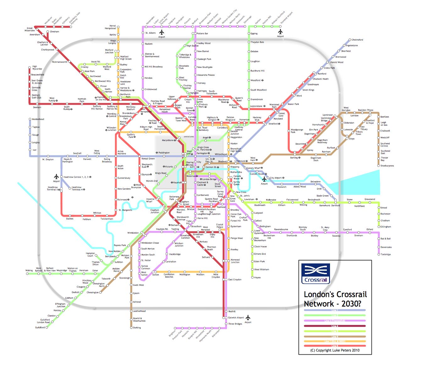
Crossrail Extrapolated - New Network Map


Whilst Crossrail Line 1 is under construction and line 2 is proposed, albeit in ambiguous form, there exist other lines and portions of lines that could be integrated into a wider Crossrail network, including Thameslink, Chiltern Railways to High Wycombe and the Metropolitan line from Baker Street northwards to create a cohesive Crossrail network across the capital, much as the RER, Cercanias and S-Bahn services do on the continent.

To an extent the Crossrail model overlaps with the role of London Underground. The difference I see should be thus: 
  • A mainline profile
  • Greater extent. Not merely urban, or suburban, Crossrail is regional, and connects with outliers and dormitories.
  • Lower station density. Especially in urban centres, Crossrail's greater scope requires fewer stops per mile to improve efficiency. As it stands, Bond Street, Tottenham Court Road, Farringdon and Liverpool Street seems one station too many.
  • Split running. Various branches and routes can be tolerated on Crossrail, more so than on LUL.
Lines which might be considered for inclusion/upgrade are the following:

1. Thameslink: already performs a "Crossrail-like" function on a N-S axis, albeit with an unusually long extension (new upgrades will see it reach from Brighton to Kings Lynn). Some of the line might be pared back in this scenario.

2. Metropolitan Line: The Met has always been an odd sausage. Conceived as a mainline commuter railway, with a few underground stations in central London. it did for a period operate as far as Aylesbury. I propose routing it under Marylebone station and the West End through Charing Cross and over south London tracks to Gatwick airport. Through platforms at Baker Street would be freed up to become terminator/reversing platforms for the Circle/Hammersmith & City lines. Of course, I envisage running services through to Aylesbury again.

3. Chiltern Line. Running closely parallel to the Met is the Chiltern Line/Railway. An operational merger of the service to High Wycombe with the Met is possible, or it could continue to run in parallel. The former is perhaps preferable in order to maintain separate track for the Chiltern services running to Birmingham, which in fact is the remnant service retainging the Chiltern franchise. This scheme would see Baker Street cease as a Met LIne terminus, both lines instead diving into tunnel under Marylebone (already saturated) and on to south and southeast London tracks.

4. LTS/London Tilbury and Southend. Not a very long line, but a connection through the city and south London out to Dorking and Orpington is possible.

In the first version London Overground is integrated fully into Crossrail. Not the variation on the original Crossrail scheme. Instead of Bond Street, a Kensal Green station is included. This is now not feasible, since construction of Bond Street Crossrail is underway. The western extension otherwise remains the same, but the southeastern route to Abbey Wood is extended down to Dartford fr useful connections with other lines.


(c) Copyright Mindroutes / Luke Peters 2010. To view LARGE VERSION, Left click on image, then right click 'view image'

In the second version London Overground is extracted and stands apart. Operation of the Metropolitan and Chiltern Lines remains distinct though they share routing from West Hampstead south as far as Charing Cross.

(c) Copyright Mindroutes / Luke Peters 2010. To view LARGE VERSION, Left click on image, then right click 'view image'

Wednesday, 2 December 2009

OVERCROWDED COVENT GARDEN - DLR TO THE RESCUE?

Covent Garden tube station, on the Piccadilly Line, is amongst the last of central London's stations with lift/stairs access only. ie. escalators have not been installed. To do so would be very difficult due to building limitations in the area.  Lifts offer much reduced station access compared to escalators which move larger numbers of people more quickly between etrance and platform. The old station finds itself inadequate to cope with the demand it faces from tourists visiting the Covent Garden Piazza and Market, especially at weekends and in summertime. Until recently the station became exit only at weekends to cope with this demand spike. New lifts have eased this. Leicester Square is not too far away, so returning passengers were directed to walk the 260m to the next station. Incidentally this is the shortest interstation distance on the London Underground network. TfL hope to install a new exit to the station which will help even more.


Passenger journeys (entries and exits) at Covent garden tube station in recent years.

This may be enough to increase the station's capacity. There is another possibility, from an unlikely direction. The DLR, Docklands Light Railway has been expanding apace in recent years. New links to Stratford iand Dagenham Dock are due to open soon and one of the next projects in the pipeline is an extension from Bank to Charing Cross in the heart of the West End. It has even been suggested it might continue on to Victoria! Well, it could be said the DLR stopped being a light railway with the introduction of three car trains. Perhaps it's not a Docklands railway any more either.

The extension would make use of the old Jubilee Line tunnels which overran from Charing Cross along the Strand as far as Fleet Street, part of the planned 'Fleet Line' which did not transpire. In the end the line terminated at Charing Cross. The tunnels, if used, would require enlargement to DLR guage. Passing along the Strand as it would, the line presents us with an interesting opportunity.

How the DLR extension to Charing Cross might look on the Tube Map. In this form it would do nothing to help Covent Garden.

It has been mooted that the line provide interchange at City Thameslink (sensibly) and also a station at the site of Aldwych station (terminus of a Piccadilly Line branch line from Holborn, now closed).

However, it would be possible to provide a station in addition to, or instead of Aldwych, further down the Strand opposite Southampton Row. This would be very close to Covent Garden Piazza (about 200m) and be almost as useful to the area as the current Covent Garden station. The map below indicates 300m radius catchments of the stations in the vicinity, existing and potential.


Station catchments around Covent Garden. Strand DLR station (at centre) would provide an excellent alternative to Covent Garden.
 
Naming the station "Strand (Covent Garden)" or somesuch would encourage the tourist, unfamiliar with London, to use the station as a Convent Garden alternative. In effect it fulfills the function of a Covent Garden station expansion.

Saturday, 28 November 2009

THE LIVERPOOL GAPS MAP

Following an idea from here:

Here is a map displaying catchment circles and gaps in Merseyside's Merseyrail system. The catchment circles are of 600m and 1000m radius.


Note the close spacing of stations in Liverpool and Birkenhead city centres and large areas around Liverpool city centre which have no station. Is this where planners perceive the distance into town is too short to warrant a train journey? Note also the various agglomerations of closely located stations with overlapping catchments.

Merseyrail is a perplexing beast. Neither true metro, nor true suburban network, somewhere in between. In the centre it displays characteristics of any classical metro system, with frequent train spacings; further out it is a suburban/provincial commuter railway like any other. Its stock is electric, but of a regular type 508 found all over Britain's provincial and suburban railways.

Particularly, the neglect of inner city Liverpool in its catchment rather rules out its usefulness as a metro to a large extent. Particularly this bias toward the outer extremities means it might best be compared to the RER routes in France or the S-bahn systems in Germany and elsewhere.

What could make Merseyrail a true metro?

1. Lighter rolling stock. I don't mean lower capacity but a 'light rail' rolling stock, say like DLR, with faster acceleration and braking. would give a different image to the network and define it as separate.

2. More lines. There is potential to reopen sections of tunnel and surface line in Liverpool. Around the inner city this could provide a more metro-type service.

3. More stations. As the gaps map shows, there are plenty of spots that might benefit from a station.

4. Segregation. Various sections of Merseyrail currently use shared track and overlap with mainline services.  The distinction needs to be made.

5. Autonomy. Complete autonomy of operation and ticketing, under the control of Merseyside Council.